
Almondsey
Fort Quadron, Estalia
When Archduke Hralrlfladenulel revived Estalian patiotism around the time of the French Revolution, he widened and paved the Northern Highway from the capital city of Lotta to the secure port of Quair on the northwest coast of North Estalia. There were several way-stations with checkpoints, small garrisons, and 'pony express' stations along the way, but the main protection was Fort Quadron on the cliffs along the north shore. This was constructed by the Duke of North Estalia (Quadro the 17th) a few miles northwest of his ancient castle. It is no major fortress of the Vauban sort, yet it remains the strongest fort in that area, and is in a very strategic position. There are three batteries for cannon -- mostly surplus naval guns from older British ships dating from earlier in the century. And there is a central moated area with accommodation for up to 150 permanently assigned troops. Quadron village, a new town, is located on the Northern Highway just south of the fortress, providing civilian support for the 'infrastructure' as well as a major staging post along the way to Quair, which is the capital town of the County of Upper March. There are also even some hardscrabble farms and crofts in this inhospitable coastal area above the moors. Before the disappearance of Almondsey there was some investigation that detected the possibility of major oil deposits in this region.
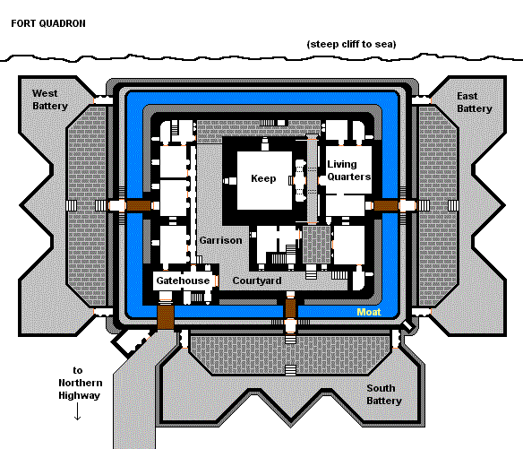 Not shown on the plan: the earthwork ravelins and bulwarks surrounding the fortress, the support areas, including barracks, stables, and barns, and the village of Quadron. The keep is a prominent landmark on the north coast and is also used as a lighthouse and observatory. There are two much smaller fort/castles (Forts Lum and Tato), one to the west, overlooking Quair, and one to the east, at Tato Bay, where the road turns south toward Ploybart and eventually the northeast frontier.
 |
 |
Two Whitcraft Towers cover the north and south inlets of Tato Bay (WT-1, or Tatohead, and WT-2, or L'Mozzian Tower). |
|